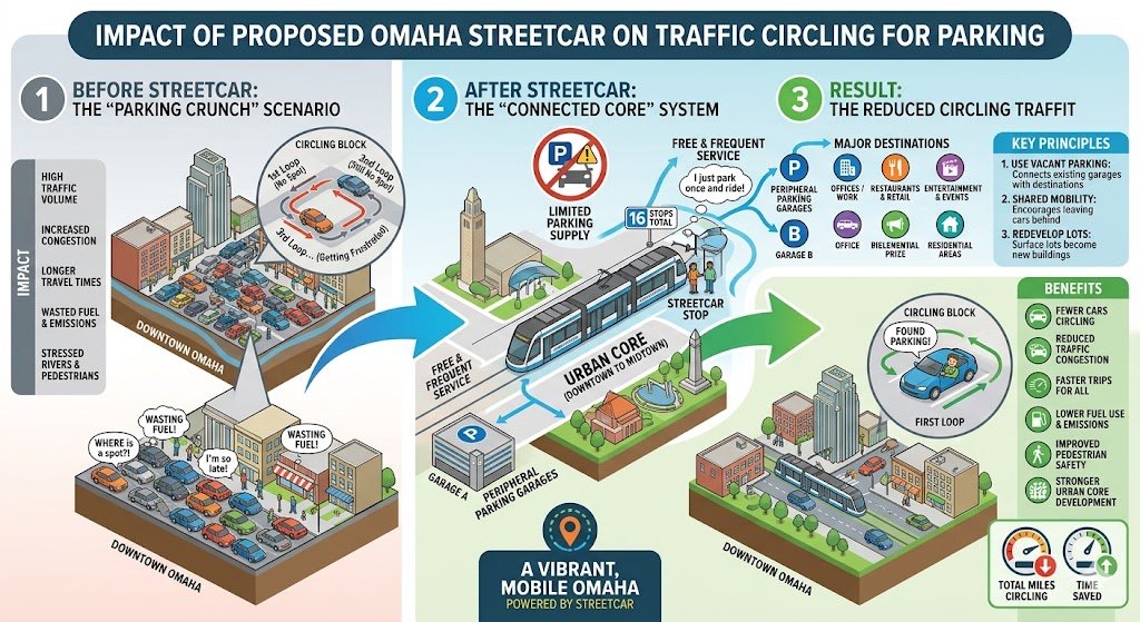
The proposed Omaha streetcar line is designed to transform how visitors, workers, and residents navigate the urban core, specifically by addressing the “parking crunch” that leads to traffic congestion and aimless circling.
The system aims to alleviate these issues through the following strategies:
Reducing Circling for Parking
Connecting Existing Infrastructure: A primary goal of the streetcar is to create a “connected core” where visitors can park once in peripheral garages or lots outside of the immediate, congested center and use the streetcar for the remainder of their trip.
Utilizing Vacant Parking: By linking transit to existing underutilized parking facilities, the system allows the city to manage parking more efficiently rather than requiring drivers to hunt for spots in the busiest, most crowded zones.
Transitioning Away from Car-Centric Planning: The streetcar encourages a shift toward a denser, mixed-use environment where residents and workers can navigate between office buildings, retail, and residential areas without needing a vehicle for every stop, effectively removing cars from the road.
mpact on Event Traffic
Events such as the College World Series or large concerts often create massive surges in traffic where thousands of attendees circle downtown streets simultaneously, searching for limited parking. The streetcar addresses this in several ways:
Seamless Event Mobility: With frequent service and a simple, easily understood route, the streetcar allows fans to park across a much larger geographic area (Midtown and beyond) and ride into the heart of the event zone.
Increased Capacity: By enabling visitors to park further away from the specific event venue, the streetcar reduces the number of vehicles competing for limited spots in the immediate vicinity of the CHI Health Center or other major destinations.
Improved Flow: Because the streetcar provides a reliable, dedicated transit option, it reduces the overall volume of “looping” traffic, leading to faster trips and reduced fuel consumption and emissions for everyone in the urban core.
Ultimately, by prioritizing movement through the urban core via transit rather than through private vehicle circulation, the streetcar project aims to make Omaha’s downtown more accessible and vibrant. As shown in the infographic “Impact of Proposed Omaha Streetcar on Traffic Circling for Parking,” this system is intended to convert a cycle of frustration—characterized by wasted fuel and high congestion—into a streamlined process where drivers park once and enjoy frequent transit.
The Tower District in Papillion, Nebraska, is a fascinating case study in modern suburban development. Spanning 112 acres at the intersection of 84th (Washington) Street and Highway 370, it is marketed as a “city within a city”—a bold attempt to inject urban energy into one of America’s fastest-growing suburban counties.
However, whether it represents a triumph of walkable urbanism or just another flavor of car-dependent sprawl depends entirely on whether you are looking at its internal design or its external connectivity.
The Case for Walkable Urbanism: “The Missing Middle”
On the inside, the Tower District breaks many of the rules of traditional suburban sprawl. It is designed around the concept of Missing Middle Housing, which fills the gap between single-family homes and massive apartment complexes.
Diverse Housing Density: Rather than rows of identical houses, the district features mansion apartments, fourplexes, townhomes, and “cottage homes.” This density is the engine that makes walkability possible.
Human-Scale Design: The master plan emphasizes narrow streets, alley-loaded garages (keeping cars off the main streetscape), and wide sidewalks. This “park once” philosophy encourages residents to leave their cars and walk to the neighborhood’s central plazas.
Mixed-Use Integration: By including street-level retail and office space, the development attempts to mimic historic downtowns like Benson or Blackstone in Omaha, where daily needs can be met within a short stroll.
The Case for Car-Dependent Sprawl: “The Island Effect”
Despite its internal charm, the Tower District faces the “island” problem common in Midwestern planning. While it may be walkable within its borders, it remains fundamentally tethered to the automobile.
Location and Connectivity: The district is bordered by Highway 370 a busy road that is hostile to pedestrians. A resident might be able to walk to a coffee shop inside the district, but they almost certainly cannot safely cross Highway 370 except at its intersection with 84th Street.
The Parking Paradox: To attract commercial tenants, developers must still provide significant surface parking. Critics on local forums have noted that while the district is “walkable,” a large percentage of its land area is still dedicated to asphalt for car storage.
Regional Transit: Papillion remains a “bedroom community” with limited public transit. For the foreseeable future, every adult living in the Tower District will likely still need a car to connect with Douglas County.
The Verdict: A Hybrid Evolution
The Tower District isn’t a “failed” walkable neighborhood; it is a transitional one. It represents a shift away from the 1990s model of cul-de-sacs and toward a more sophisticated, “urban-lite” suburbia.
Ultimately, the Tower District proves that you can build a neighborhood where it is pleasant to walk, but you cannot build a truly walkable lifestyle until the surrounding city infrastructure catches up to the neighborhood’s ambition.
The “Mile to Main”: Connecting to Downtown
The Tower District is situated approximately one mile south of Downtown Papillion. In many suburban developments, a one-mile distance is a “psychological wall” because there is no safe way to traverse it on foot. However, the Tower District bridges this gap through a few key urbanist strategies:
The 84th Street Corridor: Unlike older sections of 84th Street, the stretch connecting the Tower District to the historic downtown is being outfitted with wide, multi-use sidepaths. This allows residents to bike or walk from their “Missing Middle” townhome directly to the local shops and restaurants of the historic core without ever needing to navigate a dirt shoulder or a narrow sidewalk.
The Butterfly Landmark: The iconic Papillion Water Tower (adorned with butterflies) serves as a visual tether. By placing high-density housing at the base of this local landmark, the development creates a continuous “sense of place” that extends the feeling of the city southward, making the walk feel like a neighborhood stroll rather than a trek through a wasteland.
The Papio Trail: An Expressway for Bikes
Perhaps the most significant “anti-sprawl” feature of the Tower District is its integration into the West Papio Trail. This isn’t just a recreational loop; it is a major artery of the Omaha metro’s 150-mile trail system.
Commuter Potential: The West Papio Trail follows the creek line and connects the Tower District to Halleck Park, local schools, and eventually the Keystone Trail. For a resident of the Tower District, the trail serves as a “pedestrian and bike expressway,” providing a car-free route to major employment hubs and parks across Sarpy and Douglas Counties.
Neighborhood Integration: The master plan for the Tower District includes internal trail spurs that feed directly into the regional system. This means the “walkable urbanism” doesn’t end at the property line; it plugs into a network that reaches all the way to Bellevue and Omaha.
For over 75 years, the sweet, toasted scent of cereal has been a staple of the air near 96th and F Street in Omaha. However, that era is drawing to a close. WK Kellogg Co. recently announced the permanent closure of its Omaha manufacturing facility, a move slated for completion by the end of 2026.
The decision comes as part of a broader corporate restructuring following the company’s split into two entities (WK Kellogg Co and Kellanova). To modernize its supply chain, the company is shifting production from older, legacy sites like Omaha to more efficient, high-tech plants in Michigan, Pennsylvania, and Ontario.+1
Displaced Jobs: The Human Cost
The closure is a significant blow to Omaha’s industrial workforce. According to company filings and union reports, approximately 550 jobs will be eliminated.+1
The displacement affects two primary groups:
Production and Skilled Trades: Roughly 500 of the affected employees are union members (BCTGM Local 50G). These roles include machine operators, industrial bakers, maintenance mechanics, and forklift drivers.
Management and Administration: About 50-100 roles in plant management, quality control, and logistics coordination are also expected to be cut.
Many of these workers have spent decades at the plant, benefiting from “legacy” contracts that are increasingly rare in today’s manufacturing landscape. While Omaha’s overall job market remains vibrant, the loss of these high-paying, blue-collar positions creates a specific void for specialized manufacturing labor.
Housing Market Analysis: Impacts and Resilience
A sudden loss of 550 local incomes naturally raises questions about real estate stability, particularly in the immediate vicinity of the plant.
1. Potential Impact on Renter Households
The most immediate effect may be felt in the high-density rental corridors near the plant. Specifically, the apartments along 96th Street between I-80 and Harrison Street (such as the Vista Apartments and various complexes near the Applewood Center) cater to a workforce demographic that values proximity to the industrial hub of Southwest Omaha.
Increased Vacancy Risks: If displaced workers relocate for new manufacturing opportunities in other states, these complexes could see a temporary spike in turnover.
Rent Pressure: Conversely, because Omaha currently faces a “buyer’s market” in some neighborhoods with inventory exceeding demand, landlords in this 96th Street corridor may have less leverage to raise rents as they compete to keep units filled.
2. Broad Real Estate Stability
While the loss of 550 jobs is significant, the impact on Omaha’s broader housing prices is expected to be minimal.
Market Scale: In a metro area of nearly one million people, 550 households represent a small fraction of the total housing demand.
Sector Resilience: Omaha’s housing market has shown a 100% sale-to-list price ratio recently, suggesting that demand for homes remains balanced.
Diversification: The area near 96th and Harrison is not solely dependent on Kellogg’s; it is supported by various other logistics, retail, and tech employers that help insulate local property values from a single-plant closure.
Looking Ahead
The city of Omaha and local chambers are already coordinating job fairs to help transition Kellogg’s employees into other local manufacturing roles. While the physical plant at 9601 F Street may soon fall silent, the focus now shifts to repurposing the site and ensuring the skilled labor force finds a home in Omaha’s evolving economy.
Would you like me to look into the specific retraining programs currently available for manufacturing workers in the Omaha area?
The following video provides a deeper look into the timeline of the closure and the immediate reactions from local union leaders and city officials.
As Omaha moves into 2026, the skyline isn’t the only thing changing. Beneath the surface and along the asphalt of the urban core, the Omaha Streetcar project is reshaping the city’s relationship with transit. While supporters see a future of “total mobility,” the current reality for drivers is a complex maze of orange cones and detour signs.
The Long-Term Vision: Less Congestion through Density
The fundamental argument for the streetcar isn’t just about moving people from Point A to Point B—it’s about changing how they get there. By 2028, the streetcar is expected to offer a free, 3-mile loop connecting the Blackstone District to Downtown.
Prioritizing People over Parking: Currently, nearly 50% of Omaha’s downtown is dedicated to parking. City planners aim to use the streetcar to reduce the need for massive new parking garages, allowing that land to be repurposed for housing and retail.
Multimodal Integration: The system is designed to work with the ORBT (Omaha Rapid Bus Transit) and bike-share programs. The goal is a “park once” environment where visitors leave their cars in one spot and use the streetcar to hop between the Old Market, CHI Health Center, and Midtown.
Traffic Calming: New station designs, particularly the three median platforms on Farnam Street, are intentionally designed to slow down vehicle traffic, making the corridor safer for pedestrians.
The 2026 Reality: Construction and “Road Blocks”
While the long-term goal is a smoother flow, the construction phase has been a significant hurdle for Omaha commuters. As of February 2026, the project is “full speed ahead,” but that speed is often literal for the construction crews and figurative for the traffic.
Current Traffic Hotspots
Location
Impact
Status (Feb 2026)
8th & Farnam
Full closures for utility work
Active; Impacting CHI Health Center access
Farnam Street Bridge
Demolished for replacement
Closed for most of 2026
Turner Blvd & Farnam
Major utility intersection work
4-month full closure in progress
10th Street
Lane restrictions near Capitol Ave
Ongoing; Shifting patterns
The “Underground” Delay
A major factor in traffic congestion has been the unexpected complexity of Omaha’s old utility lines. Crews have had to use vacuum excavation to navigate a web of 19 different utility providers. This meticulous work has led to “predictable but persistent” lane closures that have frustrated local business owners and daily commuters alike.+1
Parking: The Great Reallocation
Parking remains the most contentious part of the traffic conversation. To make room for the tracks and stations, some on-street parking has been permanently removed. However, the city argues that the streetcar unlocks vacant parking stalls in existing garages that are currently underutilized during peak hours.
For now, the city has pointed drivers toward the Midtown Crossing garages (offering 2 hours of free parking) to mitigate the loss of street spots.
Note: While construction is projected to ease by late summer 2026, the transition to “mainline construction” (laying the actual tracks) means that while closures may become more predictable, they will remain a staple of the downtown commute until 2028.
As Sarpy County continues its streak as the fastest-growing county in Nebraska, the infrastructure beneath its wheels is undergoing a massive transformation. At the heart of this evolution is the South Sarpy Expressway, a multi-year project designed to reshape east-west travel and unlock the economic potential of the county’s southern corridor.
What is the South Sarpy Expressway?
Formerly known as the Platteview Road Expressway, the project was rebranded to more accurately reflect its scope. It isn’t just a road widening; it is the creation of a four-lane, access-controlled expressway that will eventually provide a high-speed link between U.S. Highway 75 in the east and Interstate 80 in the west.+1
One of the unique aspects of the plan is its “off-alignment” design. Instead of simply replacing the existing Platteview Road, the new expressway lanes will be built adjacent to it. This allows the current Platteview Road to remain in place as a frontage road, preserving local access for homeowners and farmers while the expressway handles heavy regional traffic.+1
Project Timeline and Key Phases
The project is being tackled in segments to manage the significant engineering and financial requirements.
Segment
Status / Goal
10th St. to 42nd St.
Current Focus: Final design is complete, with construction anticipated to begin in 2026.
U.S. 75 to 108th St.
Under preliminary design; includes major interchanges at 27th, 36th, 57th, 72nd, and 84th Streets.
I-80 Connection
Long-term vision to link the corridor to the Gretna area and a proposed new I-80 interchange.
Why It Matters: Growth and Safety
The surge in population in Papillion, Bellevue, and Gretna has pushed existing two-lane rural roads to their breaking point. County officials have cited several primary drivers for the expressway:
Congestion Relief: Providing an alternative to Highway 370, which currently carries the bulk of east-west traffic.
Economic Development: Improving access for industrial and commercial projects, particularly near the data center corridors in southern Sarpy.
Safety Infrastructure: Transitioning from gravel and narrow paved roads to a divided highway with modern interchanges significantly reduces high-speed collision risks.
Sewer & Utility Synergy: The road project is being coordinated with the Sarpy County and Cities Wastewater Agency to install critical sewer infrastructure simultaneously, saving taxpayer money on future excavations.
Funding and Investment
The scale of the project is reflected in its price tag. Recent county budget reports for 2026 highlight an allocation of approximately $113 million specifically for the South Sarpy Expressway. Funding is a “team effort,” utilizing a mix of:
County Highway Allocations
Federal MAPA Grants
Private Development Contributions (Developers often pay a share as their new neighborhoods or warehouses benefit from the improved access).
While the South Sarpy Expressway is often framed as a solution to growth, “bypass” projects of this scale inevitably come with significant trade-offs. For the Omaha-Sarpy metro area, the downsides generally fall into four categories: urban sprawl, economic shifts, environmental impact, and construction headaches.
1. Acceleration of Urban Sprawl
The most common criticism of a new expressway is that it creates a “build it and they will come” cycle.
Infrastructure “Creep”: By providing high-speed access to previously rural land, the expressway encourages developers to build low-density housing further away from the city core.
Increased Auto-Dependency: This pattern forces residents to rely almost exclusively on cars, increasing the total vehicle miles traveled (VMT) in the region and eventually leading to new congestion on the very road designed to solve it.
2. Economic “Bypass” Effect
When a high-speed expressway diverts traffic away from existing corridors like Highway 370 or local city streets in Springfield and Papillion, it can change the local economic landscape.
Loss of Local Business Visibility: Smaller “mom-and-pop” shops on older routes may see a drop in pass-through customers.
The “Anywhere, USA” Aesthetic: New developments along expressways tend to favor large-scale retail power centers and national chains, which can dilute the unique character of Sarpy County’s smaller communities.
3. Environmental and Quiet-Zone Degradation
Converting a rural two-lane road into a four-lane divided expressway fundamentally alters the local ecosystem.
Noise Pollution: The transition from agricultural sounds to constant high-speed tire and engine noise is a major concern for existing homeowners, particularly in areas like the Platteview Golf Club and nearby established neighborhoods.
Habitat Fragmentation: Larger roads act as barriers for local wildlife and can increase the risk of vehicle-animal collisions.
Runoff Issues: Massive increases in “impervious surfaces” (concrete and asphalt) mean more oil, salt, and chemicals wash into local watersheds during rainstorms.
4. The “Induced Demand” Paradox
Transportation planners often warn of induced demand: when you make driving easier and faster, more people choose to drive, and more people move to the area.
Obsolescence: Critics point to Highway 370 as a cautionary tale; it was intended to be a fast corridor but is now heavily congested with stoplights and turning traffic. There is a fear that the South Sarpy Expressway will eventually suffer the same fate as the metro area continues to expand southward.